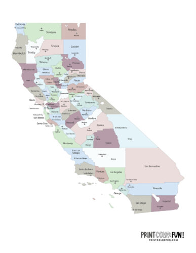
Color California map with counties and cities
California map outline coloring page
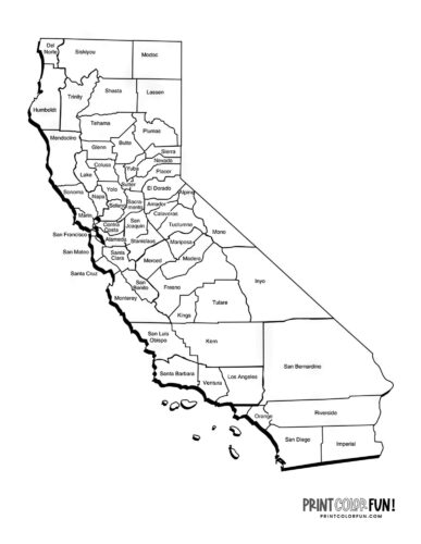
California county map coloring page
Alameda County, established in 1853 with its county seat in Oakland, is named for the extensive oak woodlands that once characterized the region; “alameda” in Spanish refers to an avenue lined with trees. It spans 738 square miles and is home to 1,628,997 residents.
Alpine County was founded in 1864 and its county seat is Markleeville. It’s named for its high altitude in the Sierra Nevada, reminiscent of the European Alps. The county covers 739 square miles and has a small population of 1,190.
Amador County, with a population of 41,412, has its county seat in Jackson. Named after Jose Maria Amador, a notable gold miner, this county was established in 1854 and covers 606 square miles.
Butte County was established in 1850 with its county seat in Oroville. Named for the Sutter Buttes, which were once thought to be within the county, it covers an area of 1,640 square miles and supports a population of 207,303.
Calaveras County‘s county seat is San Andreas, established in 1850. Its name comes from the Calaveras River, with “calaveras” meaning “skulls” in Spanish. The county spreads across 1,020 square miles and has a population of 46,563.
Colusa County, with the county seat of Colusa, was also established in 1850. It’s named after the Rancho Colus land grant from Mexico. Covering an area of 1,151 square miles, it has a population of 21,914.
Contra Costa County‘s seat is Martinez, established in 1850. It sits across the San Francisco Bay from San Francisco, with its name meaning “opposite coast” in Spanish. The county covers 720 square miles and has a substantial population of 1,156,966.
Del Norte County, with its county seat in Crescent City, was formed in 1857. Its name means “northern” in Spanish, aptly named for its location along California’s northern border. The county’s area is 1,008 square miles and it has a population of 27,082.
El Dorado County‘s seat is Placerville, established in 1850. The county’s name is inspired by the mythical city of gold, El Dorado, reflecting its importance during the California Gold Rush. It encompasses 1,712 square miles and houses 192,646 residents.
Fresno County has its county seat in the city of Fresno and was founded in 1856. The name “fresno” translates to “ash tree” in Spanish. This county is one of the larger ones, covering 5,963 square miles, with a population of 1,015,190.
Glenn County, established in 1891 with its county seat in Willows, is named after Hugh J. Glenn, a prominent California businessman and politician. It covers an area of 1,315 square miles and has a population of 28,339.
Humboldt County, with Eureka as its county seat, was named in 1853 after the German naturalist and explorer Alexander von Humboldt. The county encompasses 3,573 square miles and is home to 135,010 residents.
Imperial County, formed in 1907 with El Centro as its county seat, gets its name from the Imperial Valley, which was named after the Imperial Land Company. It spreads across 4,175 square miles and has 178,713 inhabitants.
Inyo County, with its county seat in Independence, was established in 1866. The name Inyo has a disputed etymology; it might refer to local mountains or a Mono Indian leader. Its vast area is 10,192 square miles, housing 18,718 people.
Kern County‘s county seat is Bakersfield, named in 1866 after Edward Kern, the cartographer for John C. Fremont’s expedition. This county’s 8,142 square miles are home to 916,108 individuals.
Kings County was established in 1893, with Hanford as the county seat. It’s named after the Kings River, which had the original Spanish name “Rio de los Santos Reyes” (River of the Holy Kings). The county has an area of 1,390 square miles and a population of 152,981.
Lake County, with its seat in Lakeport, was named in 1861 after Clear Lake. It covers an area of 1,258 square miles and has a population of 68,191.
Lassen County, established in 1864 with its county seat in Susanville, is named after Peter Lassen, a Danish naturalist and explorer. It encompasses 4,558 square miles and has 29,904 residents.
Los Angeles County, with the vast city of Los Angeles as its county seat, was established in 1850. Its name is derived from the original Spanish name “El Pueblo de Nuestra Señora la Reina de los Angeles del Río de Porciúncula”. With an area of 4,060 square miles, it is the most populous county in the U.S. with 9,721,138 residents.
Madera County, whose county seat is the city of Madera, was created in 1893 for the lumber industry it supported; “madera” means “wood” or “timber” in Spanish. It spans 2,138 square miles with a population of 160,256.
Marin County, with its county seat in San Rafael, was established in 1850 and is named after Chief Marin, a leader of the Coast Miwok people. The county covers 520 square miles and has a population of 256,018.
Mariposa County, with the county seat of Mariposa, was named in 1850 after the Spanish word for “butterfly”. It covers 1,451 square miles and has 17,020 inhabitants.
Mendocino County, with its county seat in Ukiah, was established in 1850 and named after Antonio de Mendoza, the first viceroy of New Spain. The county area is 3,509 square miles with a population of 89,783.
Merced County, with Merced as its county seat, was named in 1855 after the “El Río de Nuestra Señora de la Merced” (River of Our Lady of Mercy). It encompasses 1,929 square miles and has a population of 290,014.
Modoc County, whose county seat is Alturas, was formed in 1874 and is named after the Modoc people. It covers an area of 3,944 square miles with a population of 8,511.
Mono County, with its county seat in Bridgeport, was established in 1861. It’s named after Mono Lake, derived from “Monachi”, a Yokuts term for native peoples of the Sierra Nevada. The county stretches over 3,044 square miles and has a population of 12,978.
Monterey County, with Salinas as its county seat, was established in 1850 and named after the Viceroy of New Spain, Gaspar de Zúñiga, 5th Count of Monterrey. It spans 3,322 square miles and has a population of 432,858.
Napa County‘s origin is disputed but may derive from the Patwin word “napo” meaning “home.” Its county seat is Napa, covers 754 square miles, and has 134,300 residents.
Nevada County, established in 1851 with Nevada City as its county seat, is named for the snow-covered Sierra Nevada. The county covers 958 square miles and has a population of 102,293.
Orange County was named for the oranges that symbolized its semi-tropical appeal to settlers. Santa Ana is the county seat, and the county’s area is 948 square miles, supporting 3,151,184 people.
Placer County, established in 1851 with Auburn as its county seat, is named after the placer mining activities during the Gold Rush. It spans 1,407 square miles and has a population of 417,772.
Plumas County, named for the Spanish word for “feathers,” referring to the Feather River, has Quincy as its county seat. It covers 2,554 square miles with a population of 19,351.
Riverside County, established in 1893 and named after its county seat Riverside, which is located by the Santa Ana River, covers 7,208 square miles and houses 2,473,902 residents.
Sacramento County‘s seat is the city of Sacramento, named after the “Most Holy Sacrament.” Established in 1850, it spans 966 square miles and has a population of 1,584,169.
San Benito County, established in 1874 with Hollister as the county seat, is named after Saint Benedict. It covers 1,389 square miles with a population of 67,579.
San Bernardino County, with its seat in the city of the same name, was named after Saint Bernardino of Siena. Established in 1853, it’s the largest county by area in the U.S. at 20,062 square miles and has 2,193,656 residents.
San Diego County was named after the city of San Diego, which comes from Mission San Diego named for Saint Didacus. Its county seat is San Diego, and it covers 4,204 square miles with a population of 3,276,208.
San Francisco, named after Saint Francis of Assisi, is both a city and a county, established in 1850. It’s the smallest by area at 47 square miles but densely populated with 808,437 residents.
San Joaquin County, named after Saint Joachim, has its county seat in Stockton. Established in 1850, it covers 1,399 square miles and has a population of 793,229.
San Luis Obispo County, named after Saint Louis of Toulouse, has its county seat in the city of the same name. Established in 1850, it spans 3,304 square miles and has 282,013 residents.
San Mateo County, with its county seat in Redwood City, was named after Saint Matthew and established in 1856. It covers 449 square miles with a population of 729,181.
Santa Barbara County, named after the city of Santa Barbara which in turn was named for Saint Barbara, has its county seat in the city of Santa Barbara. Established in 1850, it covers 2,738 square miles and has 443,837 residents.
Santa Clara County, established in 1850 with its county seat in San Jose, is named after the Mission Santa Clara de Asís, honoring Saint Clare of Assisi. It covers 1,291 square miles and has a population of 1,870,945.
Santa Cruz County, with its county seat in Santa Cruz and founded in 1850, is named after the Mission Santa Cruz, which translates to “holy cross”. The county spans 446 square miles with a population of 264,370.
Shasta County, named after Mount Shasta and the indigenous Shasta people, has its county seat in Redding. Established in 1850, it covers 3,786 square miles and has 180,930 residents.
Sierra County, with Downieville as its county seat, was founded in 1852. “Sierra” is Spanish for “mountain range”, reflecting the area’s landscape. It encompasses 953 square miles and has a population of 3,217.
Siskiyou County, with its seat in Yreka and established in 1852, is named after the Siskiyou Mountains, although the name’s origin is disputed. It covers 6,287 square miles and houses 43,660 people.
Solano County, founded in 1850 with its county seat in Fairfield, is named after Chief Solano of the Suisunes. The county’s area is 828 square miles with a population of 448,747.
Sonoma County, with its seat in Santa Rosa and established in 1850, has a name of disputed origin, likely a Pomo word meaning “valley of the moon”. It spans 1,576 square miles with 482,650 residents.
Stanislaus County‘s county seat is Modesto, named after the Stanislaus River which honors Estanislao, a native leader. Established in 1854, it covers 1,495 square miles and has a population of 551,275.
Sutter County, with its county seat in Yuba City and established in 1850, is named after John Sutter, a Swiss pioneer during the Gold Rush. The county encompasses 603 square miles with 98,503 inhabitants.
Tehama County, established in 1856 with its county seat in Red Bluff, is likely named after a native term relating to its location. It covers 2,951 square miles and has a population of 65,245.
Trinity County, with its county seat in Weaverville, was named in 1850 after the city of Trinidad, Spanish for “trinity”. It spans 3,179 square miles with 15,781 residents.
Tulare County, with its seat in Visalia, was established in 1852 and is named after the tule rushes around Tulare Lake. It covers 4,824 square miles with a population of 477,544.
Tuolumne County‘s county seat is Sonora, established in 1850, and its name is likely from the native term “talmalamne” referring to local cave dwellings. It encompasses 2,236 square miles with 54,531 residents.
Ventura County, with its seat in the city of Ventura, was named after the Mission San Buenaventura, honoring St. Bonaventure, in 1872. It covers 1,846 square miles and has 832,605 inhabitants.
Yolo County‘s county seat is Woodland, named after the Yolan Native American tribe. Founded in 1850, it spans 1,012 square miles with a population of 222,115.
Yuba County, with its county seat in Marysville, was established in 1850 and may be named after a Maidu village or the Spanish word for “grape”, “uva”. It covers 630 square miles and has 84,310 residents.


